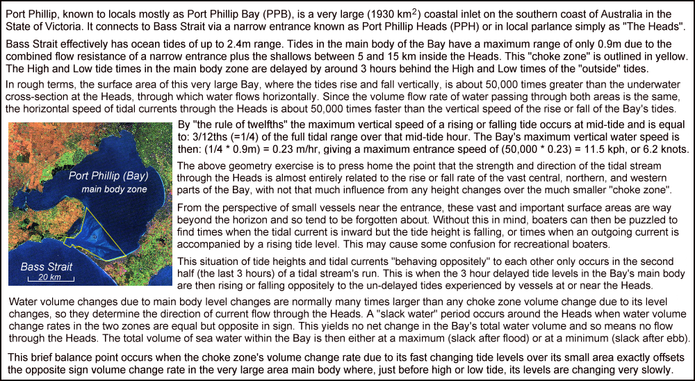
This is the Index Page for Jake's website about Port Phillip Bay's Tides and Currents. The site's purpose is to
promote a more accurate (and safer)
understanding of the tides and the strong currents in the southern part of Port Phillip.
Posts linked to this index page will introduce you to this "better story" of Port Phillip's tides, and properly explain how the strength of the entrance
current is related to the time varying difference between the "inside" and "outside" water levels.
The posts contain numerous sea height and tidal current "maps", animations, graphs, diagrams and pictures. These will help you overcome a major
psychological stumbling block which is understanding that a tidal stream does not stop and reverse when the levels become equal, as is widely believed,
but instead flows onwards (and upwards) for a while before slack water occurs. Although this is at odds with most other accounts of currents through
Port Phillip Heads, it is nonetheless true and is supported by all the evidence.
This website contains properly researched information about how, why, and when, "Slack Water" occurs at Port Phillip Heads. The worldwide web hosts lots of content on this and related topics from many "self-appointed tide experts". Some of this is true, some quite bad, and some of it is is downright dangerous. Why should you think this site is any different? Well that is a judgement you will have to make for yourself. Some points in my favour are:-
* Fifty years of experience in water based activities in the strong tidal areas at and near the Heads:- power boating, sailing, scuba diving, and kayaking.
* Although now long retired, I trained in scientific research methods and completed a Physics PhD. That training allows me to frame the right questions in
need of an answer to aid our understanding of the Bay. Then, either by calculation or by doing measurement experiments, I could determine those answers.
* On the web I believe (and try to practice) that all conclusions drawn, or claims made, must be evidence-based. This is particularly so where the topic may have related safety implications. It is also highly preferable to have multiple threads of evidence that point to each conclusion or claim.
* My wife says I am somewhere "on the spectrum", obsessing over detail and accuracy. I'm also a good observer of nature, seeing details others may miss.
* Over the last decade I have computed and used my own "slack water tables", which has extra information to help maintain my safety as I get older. That work uses a different algorithm to the official tables but the results are very similar. On several occasions this work has been used to identify formatting or other errors in the official BoM slack water tables. These were then corrected and republished by the BoM.
* In 2023 I collaborated with CSIRO tidal modellers to introduce a "Port Phillip zoom insert" into their national tidal model public data display. Sea height and tidal current graphs were also then introduced, as well as having better time-targeted "maps" to allow users to find slack water occurrences more easily. That CSIRO work fully supports the major claims made on this website. A link to their system is given at the bottom of several of my posts. I encourage you to explore it as a very credible second source of information.
The original posts (#1, #2 & #3) are rather detailed and a bit technical, intended mainly for folk in the port authorities or other tide buffs. Some feedback suggested that some slightly simpler offerings would gain wider readership and so be more effective. To preserve cross-references between the older posts, the three new "lighter posts" are numbered as #0_A and #0_B, and #0_C.
Although the numbering might suggest a reading order, I am more than happy for you to "dip in" wherever you fancy. If you are time-poor, then Post #0_A is a short pdf file that can be downloaded and read at a later time. It gives an overview of this project. Others with more time and interest might like to view POST #1 first for a fuller outline, followed by POST #0_C which gives a comprehensive treatment of Port Philip's tide curves. If you find there is way too much text for your liking, then just browsing through the pictures may return some value for a smaller time investment.
POST #0_A The link and title is: Port Phillip Heads Tidal Streams - way past time for a better story ---> This one is a short pdf file for download. It gives an introduction to the problem.
POST #0_B The link and title is: Port Phillip: Basic Water Flow Principles ---> Why the common story fails us.
POST #0_C The link and title is: Understanding Port Phillip's Tide Curves ---> Detailed look at tide & current curves. Some useful learnings here!
POST #1 The link and title is: Port Phillip Heads Slack Water Quiz:- And The Winner Is: ---> About the quiz & why the results were disappointing.
POST #2 The link and title is: Port Phillip and 3 "Bad Boy" Slack Water Myths ---> If you do believe in any of these myths, please don't!
POST #3 The link and title is: Sea Surface Slopes in Port Phillip ---> What really drives the tides and currents inside Port Phillip.
In my years on, in, and under the sea I saw many folk have their day ruined, or put themselves in danger, by a poor understanding of tidal currents in this area. The most serious case was when I stumbled on a drowning man found drifting alone in the sea. He was right at death's door, blue faced and in very desperate need of being rescued. He was in that situation because of his belief in one of three dangerous, but still common, "urban tidal myths" that have grown up around Port Phillip's tides.
None of these three myths are true, and none is supported by any evidence whatsoever. However they persist at some (hopefully) dwindling level within the recreational boating, sailing, and diving communities. Any of these myths could potentially create a "threat to life" situation, just like the one I encountered.
My traumatic and still haunting "eyeball-to-eyeball" experience of a near drowning gave me a resolve to try to eliminate each of these dangerous "tidal myths" and replace them with a better understanding of tides around the Heads. This task has proved much harder than it sounds because so many folk want to hold on tightly to ideas they have thought to be true over very long periods of time. They then block out any invitation to rethink things through, or even examine, in an unbiased way, the mountain of evidence and measurements against these myths.
This struggle is also hard not only at the level of water sports organisations, but even at the official government level where it appears that the simplicity of the tidal advice it offers is valued more highly than its safety. These are extremely disappointing outcomes, particularly as many of the folks in those camps often loudly trumpet that they maintain a very strong "safety culture".
Some years back I ran a "Port Phillip Heads Slack Water Quiz" among a selection of folk who frequent Port Phillip Heads. Sadly 85% or more of the responses were incorrect. Only a professional Ship's Pilot and a handful of serious Bass Strait cruising sailors clearly demonstrated a good knowledge of how the entrance current behaves as a tidal stream reverses. It is likely that those serious players obtained their knowledge and understanding from reading higher level sources such as the "AusTides" publication from the navy run Australian Hydrographic Office.
It seemed likely the many who failed to identify the correct quiz answer had relied on more lower level sources for their information such as websites from water sport retailers, recreational fishing clubs, government departments, or their own organisation's internal "tide guru". Many of these sources just parrot one or more of the incorrect myths about slack water mentioned above. It is a sad state of affairs for the thousands who operate vessels in or near Port Phillip Heads that any web search on the topic will yield links and summaries that 99% of the time contain one or more untrue statements about how the tides and tidal currents behave around the Heads.
This website aims to redress that situation for those who wish to more safely enjoy the magnificent waters either at Port Phillip Heads, or anywhere in the "choke zone" inside the Heads where the sizeable and changing currents still demand respect.
*************************************************************************************************************